Brasilia National Park


Brasília, Distrito Federal, Brazil
Suggest Place to Visit
700
Track to location with GPS |
 |
The Brasília National Park, better known by the nickname "Água Mineral", is a Brazilian conservation unit with integral protection to nature located northwest of the Federal District and in the central region of the state of Goiás.
The park covers an area of 42 383 ha, about 423 8 km², with territory distributed over the administrative regions of Brasília, Brazlândia and Sobradinho and the municipality of Padre Bernardo. Its administration is currently the responsibility of the Chico Mendes Institute for Biodiversity Conservation (ICMBio).
During the gold cycle, the extractions made in the Pirenópolis region, in Goiás, were transported to the coast of Bahia, passing through the region where the park is located today. There, there was the "counting", which gave its name to the chapada existing in the place.
The creation of the park, on November 29, 1961, is directly related to the construction of Brasília. Agreement with the Ministry of Agriculture allowed Novacap to maintain a nursery for the afforestation of the new capital, in part of the area of the future park.
Attractions
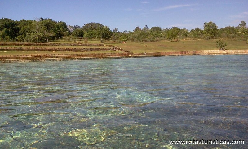
The main attraction of the park are the pools formed from the water wells, which emerged on the banks of the Camp Stream due to the sand extraction done before the creation of Brasília. The park also has two trails in the inner area, that of Capivara, lasting about 20 minutes, and that of Cristal Água, lasting about 1 hour.
Climate
The predominant climate in the region, according to the Köppen classification, is "tropical Savannah", with the concentration of rainfall in the summer. The rainy season starts in October and ends in April, representing 84% of the annual total. The rainiest quarter is from November to January, with December being the month with the highest rainfall of the year. The dry season runs from May to September, and in the driest quarter (June / July / August), precipitation represents only 2% of the annual total. In terms of annual totals, the average annual rainfall in the Federal District varies between 1,200 and 1,700 millimeters.
The relative humidity of the air drops from values above 70%, at the beginning of the drought, to less than 20%, at the end of the period. Coinciding with the hottest period, in the months of August and September, the humidity can reach 12%, typical dryness of desert (FERRANTE et al, 2001).
Although the climate of the Federal District is classified as tropical, people's thermal perception depends on the combination of different climatic elements, such as: temperature, relative humidity, vapor pressure, ventilation and solar radiation. Thus, the low humidity of the air in the dry period, combined with prolonged exposure to the sun, causes a sensation of discomfort. However, this discomfort is mitigated by exposure to the winds (FERRANTE et al, 2001).
The climate of the Federal District is represented by three units, according to Köppen: Aw, Cwa, Cwb. (ATLAS DO DISTRITO FEDERAL, 1984).
The Aw unit has a monthly temperature above 18 ° C. This unit is not registered inside the National Park of Brasilia, as it is located at an altitude of more than a thousand meters.
The climate of the CWa regime is conditioned to the temperature of the coldest month, below 18 ° C and the hottest month, with an average above 22 ° C. This temperature regime occurs in almost the entire portion of the Brasília National Park with altitudes below 1,200 m.
The climate for the CWb unit has a temperature in the coldest month below 18 ° C and the hottest month, with an average below 22 ° C. This unit corresponds to the highest portions of the Federal District. The park area is located in Chapada da Contagem, along the entire north and west extension of the current conservation unit.
Hydrography
The hydrography of the study area is formed by streams that are born in the contact of the Chapada da Contagem with the Depression of Paranoá. The streams that are located in the National Park of Brasilia are tributaries of the Paranoá River. According to Novaes Pinto (1986), the hydrography network in relation to the Paranoá Semidome has an annular pattern. Locally, these water courses have a pattern that is normally parallel in the west-east direction with a slight curvature towards the southeast towards the Paranoá lake. In the steeper portions, where shallow soils such as Cambisols are located, the drainage networks are denser, especially in the escarpment unit. This is because the shallow soils have low infiltration capacity and quickly become saturated, providing surface runoff, which forms the ravines. In some humid spots in the National Park of Brasília there are small lagoons, which can be seen in satellite images. The main sub-basins of the Brasília National Park are the Bananal stream and the Torto stream, which has the Santa Maria stream as its main tributary. This stream feeds the dam of the same name and occupies the largest basin area in the park. In the high portions, Córregos Três Barras and Córrego Tortinho stand out, which bathes a large extension of the National Park.
Comments
We don´t have yet any comments about:
Brasilia National Park
Brasilia National Park
Be the first to leave a comment as it is very important to inform other people
Outros locais a visitar
Within a radius of 20 km from:Brasilia National Park
Unfortunately we do not have information on other places to visit in this area yet
Hotel reservation near Brasilia National Park within a radius of 20 km
No results
Why to book with TURIS BRASIL
The best prices
Our partnerships with the world´s largest operators offer research on the best market prices.
More options
At Rotas Turisticos you can book the hotel, buy the air ticket, book the transfer from the airport to the hotel and vice versa, book the local excursions, rent the car, take travel insurance and consult the places to visit and where to go.
Holiday Tips & Destinations
Hundreds of holiday destinations with all the options that allow you to easily choose the destination that best suits your dream vacation.
TURIS BRASIL
Links
Follow us on social networks


